


Tenstrike Voting District, Beltrami County, Minnesota
About
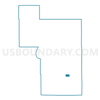
Outline

Summary
| Unique Area Identifier | 601171 |
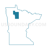
| Name | Tenstrike Voting District |
| County | Beltrami County |
| State | Minnesota |
| Area (square miles) | 4.47 |
| Land Area (square miles) | 3.26 |
| Water Area (square miles) | 1.21 |
| % of Land Area | 72.92 |
| % of Water Area | 27.08 |
| Latitude of the Internal Point | 47.65948340 |
| Longtitude of the Internal Point | -94.68396510 |
Maps

Graphs
Select a template below for downloading or customizing gragh for Tenstrike Voting District, Beltrami County, Minnesota


Neighbors
Neighoring Voting District (by Name) Neighboring Voting District on the Map
- Hagali Twp. Voting District, Beltrami County, MN
- Hines Twp. Voting District, Beltrami County, MN
- Port Hope Twp. Voting District, Beltrami County, MN
- Taylor Twp. Voting District, Beltrami County, MN
Top 10 Neighboring County Subdivision (by Population) Neighboring County Subdivision on the Map
- Hines township, Beltrami County, MN (689)
- Port Hope township, Beltrami County, MN (673)
- Hagali township, Beltrami County, MN (372)
- Tenstrike city, Beltrami County, MN (201)
- Taylor township, Beltrami County, MN (104)